71-10-21 and 64-89-??
Points on a compass have little meaning to most people. Schoolchildren learn about the north and south poles, that the earth is tilted on its axis as it travels around the sun, and that the globe is divided into latitude and longitude lines. Most come to know that the equator separates northern and southern hemispheres, and that the latitude lines defining Arctic and Antarctic circles are set at 66 degrees thirty minutes north and south of the equator which is at zero. But it’s a fact long forgotten by most adults. In truth, there’s little reason to know exactly where one is on the globe at any given point in time, unless you have a precise need to navigate to a destination. Airline pilots and ship captains need that knowledge, but casual travelers really do not.
For what it’s worth, however, the coordinates of Hot Springs Village are 34.6720 degrees N, 92.9988 W. It won’t replace a street address, but if you’re interested in little-known facts, make a note! I once was tempted to have the coordinates of the tiny train depot in my favorite little village in Maine printed on a t-shirt, just to see if anyone would ask what the numbers meant. I didn’t.
Ancient mariners noted the crossing of that zero latitude line regularly, and it is an honored tradition still practiced by sailors today. If you have been lucky enough to sail across the equator, you may know about the good-natured and sometimes raucous festivities that mark that passage. Read about the Royal Navy’s Crossing the Line ceremony aboard the aircraft carrier HMS Queen Elizabeth on the ship’s first equator crossing in 2021. I also have a certificate of passage across the equator. It is colorful and ornate, and it is not mine, but it is part of my family history.
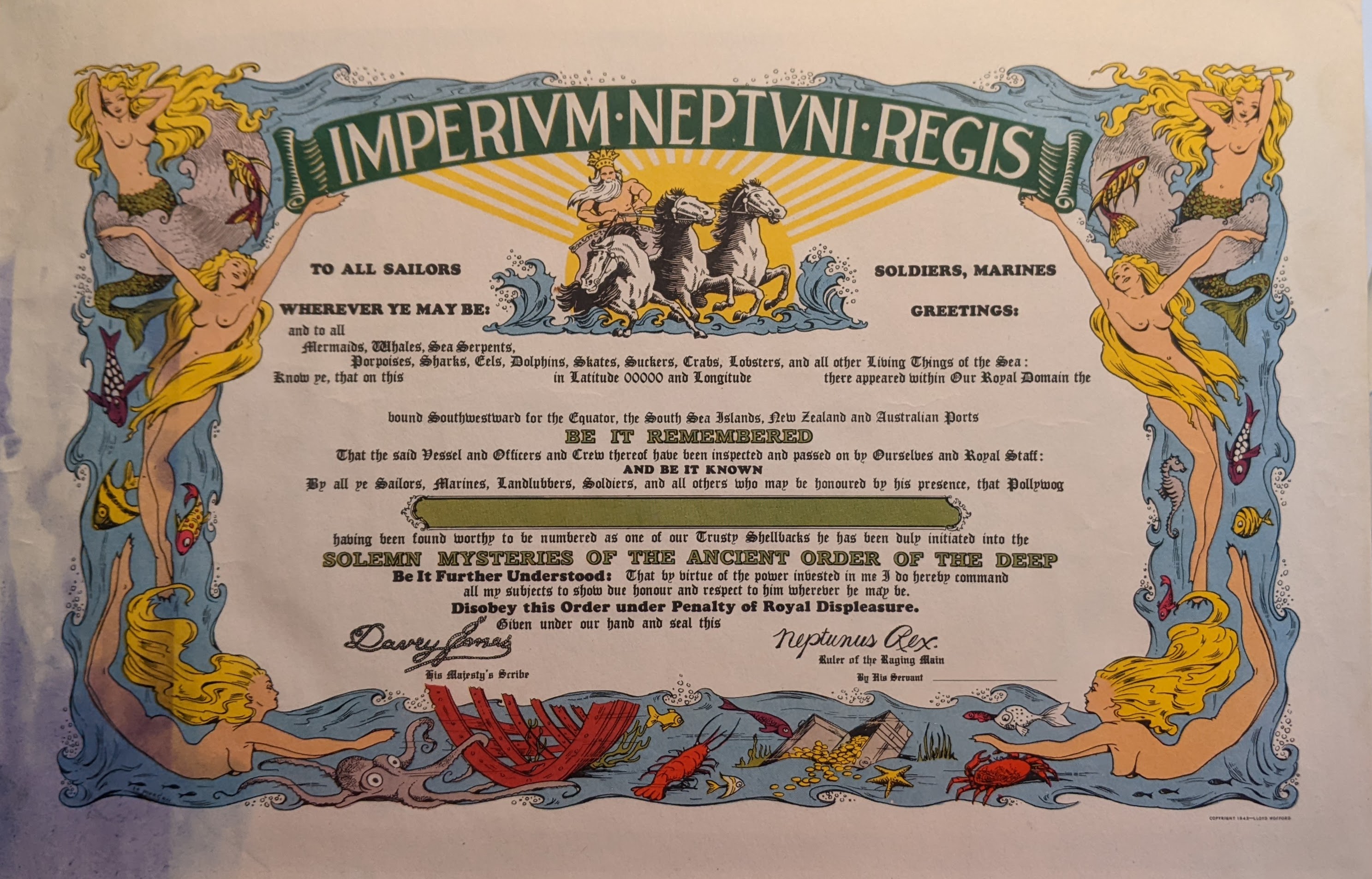
The latitude is noted as 0000 — the equator. The longitude is left blank, as are other blanks for the name of the ship, the name of the sailor, and the date and time. On the back, however, is this handwritten note:
Longitude “Secret.” USS Admiral Benson. Destination: “On a Mission of War” Date: “Secret 1945.”
I find it fascinating that some traditions were kept even during wartime. Celebrations take place aboard modern cruise ships, to the delight of most passengers. And crossing the International Date Line can be a bit disorienting. At basically 180 degrees longitude, or half the globe away from Greenwich, England, at Longitude 0, the date line was only designated as such in 1884, to make timekeeping more consistent. The line, which designates the change of calendar dates, sometimes follows a zigzag path around political boundaries, as between eastern Russia and the Aleutian Islands of Alaska. Gaining or losing an entire day in an instant while crossing the International Date Line must be disorienting as well as exciting. Crossing from east to west means that travelers “lose” an entire day! You can gain that day back if you return later to your starting point. That must be disorienting as well as exciting. I don’t know if a certificate exists for that or not!
Some airline pilots will also announce the crossing of the equator, or the time-altering effects of crossing the International date line.
Breaking the Barriers
Tourists can easily venture north of the Arctic Circle on Scandinavian itineraries, whether on land, sea or in the air. Travel to Antarctica typically requires a sea voyage, and is only possible during the height of the southern hemisphere summer. A commemorative certificate is commonly awarded to passengers, denoting the actual southern latitude a vessel reached, but traditions vary. Most visitors to Antarctica do not actually cross into the Antarctic Circle. Most don’t get even to 65 degrees south latitude — the passages are too treacherous for all but sturdy scientific vessels with ice-breaking ability. There are no scheduled flights to the seventh continent from either South America or Australia. Scientists and researchers most often arrive by air at their remote research stations in late spring and depart the same way prior to the onset of the long Antarctic winter.
The earth’s magnetic poles continue to shift slightly, and the imaginary lines that describe the polar regions also vary somewhat. The boundaries of the polar circles are typically noted as 66-33-39 degrees North or South latitude. They are sometimes said to be situated at 66.5 degrees. There are only about 69 miles between degrees of latitude, so the difference is truly miniscule.
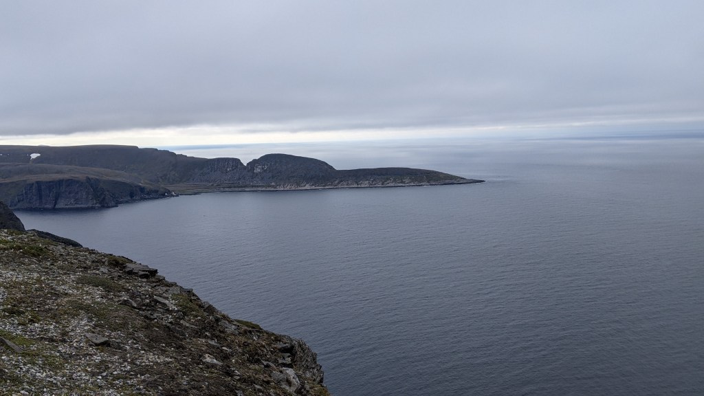
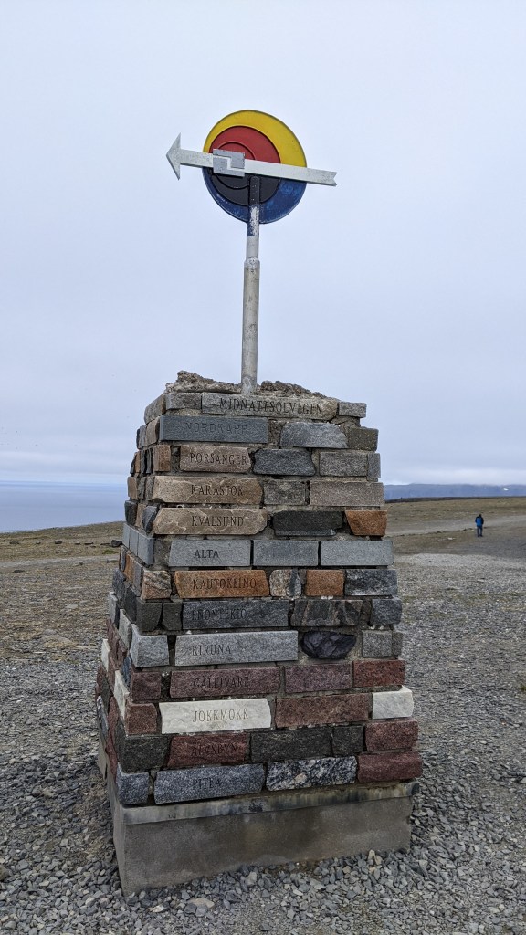
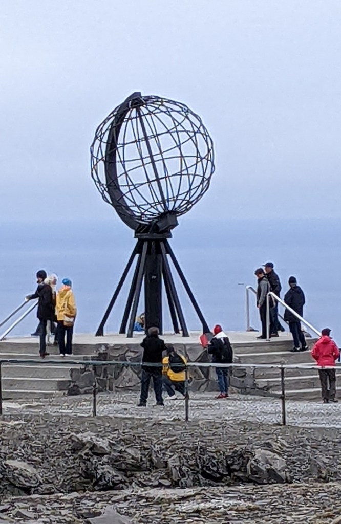
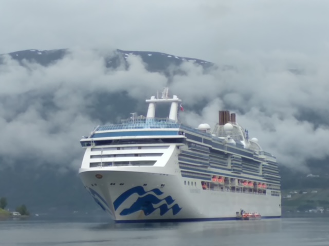
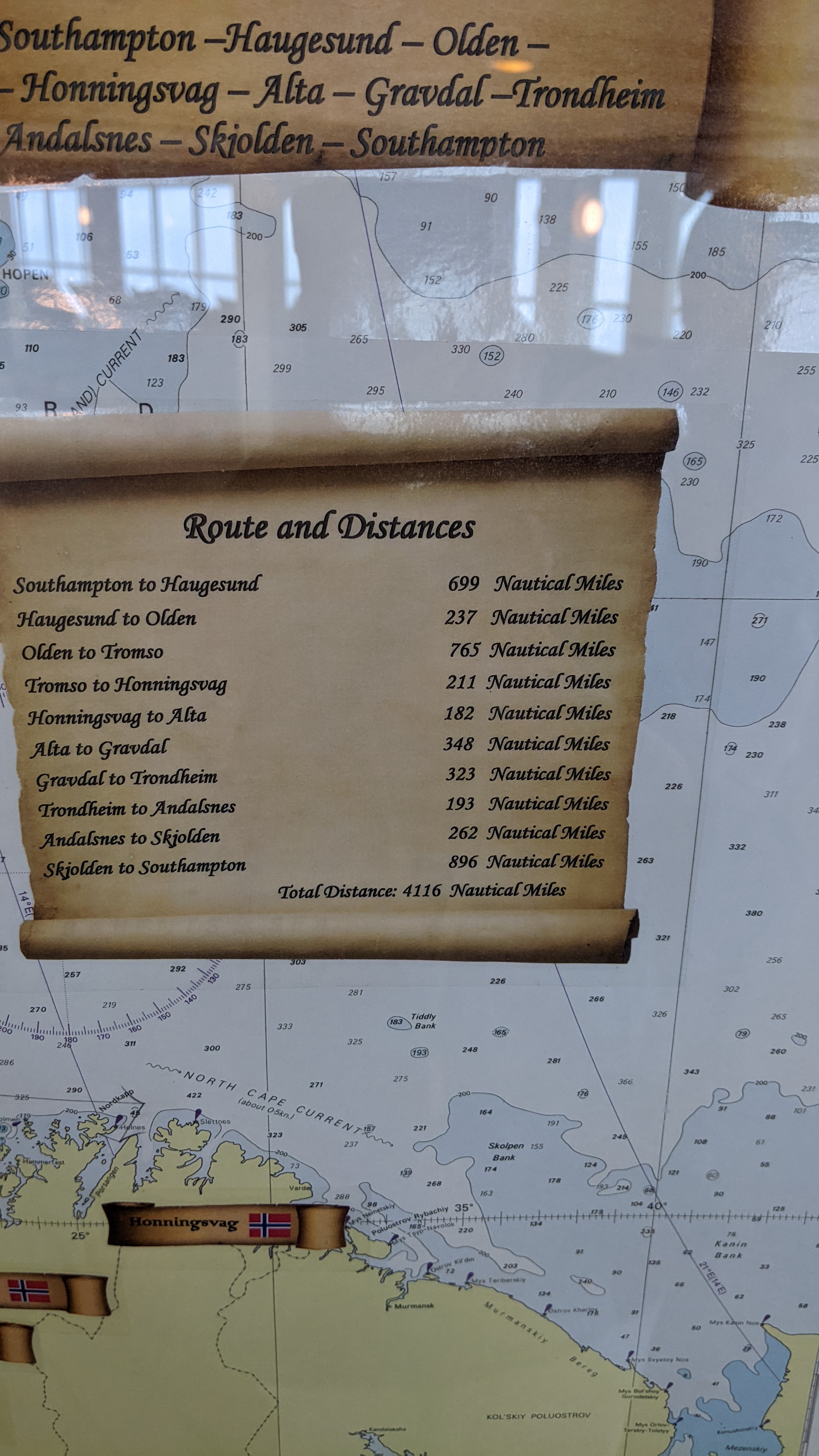
When my husband and I cruised along the coast of Norway in 2022, we entered into the Arctic Circle, according to our certificate, at 12:12 a.m. on June 17, at Latitude 66-30.1 N Latitude and Longitude 009-26.3 E. We continued north to Nordkapp, or the North Cape, at 71-10-21, the northernmost point of the European continent, and also to Skarsvag, a Norwegian fishing village with a population of 60, at latitude 71-06-47 N.
Approximately seven months later, we sailed from Ushuaia at the southern tip of Argentina across Drake Passage and along the Antarctic Peninsula, achieving a “most southerly latitude of 64 degrees 58 minutes.” The date and time are not noted on that certificate.
Next month, I will travel along the Dalton Highway, which runs north from just outside of Fairbanks to end at Deadhorse, Alaska, close to the Arctic Ocean. There’s a simple wood sign at about milepost 115 on the roadway, at which vehicles traditionally stop for photos. The sign, depicting the earth as viewed from the North Pole, simply reads “Latitude 66 33”. The 414-mile highway, some of it still only hard-packed gravel, was built to facilitate construction of the Trans-Alaska Pipeline. The pipeline itself stretches for 800 miles, from Prudhoe Bay in the north to Port Valdez, where the oil is loaded onto tankers for shipment to market.
Why do I do these things?
Well, for one reason, like Captain Kirk, I like to go where few other people have been. Secondly, I am especially fond of quirky destinations, and I will go out of my way for the photo ops and the unique experiences they provide. I like to stand at points where the land ends and the sea begins, and imagine what lies beyond. Many of these “furtherest” points fill me with a sense of wonder that past explorers, sailors, and adventurers stepped out into the unknown not knowing where exactly their journeys would take them, when they would end, or if they would ever return.
Just for the fun of it while we were boating in Maine, my husband and I visited Lubec, Maine, the easternmost point of the continental United States. Nearby are the distinctive red and white striped West Quoddy Head Light in Maine, and the historic East Quoddy Head Lightstation which stands at the most northern point of Campobello Island, New Brunswick, Canada. The names confused us until we consulted our navigational chart and realized that they designate opposite sides of Quoddy Narrows, and make perfect sense to local mariners, as they have for nearly two centuries.
We have returned to Key West many times to stand at the southernmost point buoy. Just for reference, latitude and longitude readings there are 24.5465 N, 81.7975 W. The northwesternmost and most western points of the contiguous 48 states are near Cape Flattery on the Olympic Peninsula in Washington state. Despite living in Washington for many years and boating in the waters around Puget Sound and the peninsula, I have not been there. Maybe someday.
Trips to Gibraltar give us reason to look longingly across the Staight that separates Africa from Europe — a mere eight miles. A trip to Portugal several years ago found us enthralled with the lighthouse at Cabo Sao Vicente, the southwesternmost point of Europe. It is said that it can be seen from 60 miles out to sea. And, yes, I have an ongoing fascination with lighthouses!
It is at these times, as I stand in these faraway places, I realize anew just how vast and beguiling this earth we call home truly is, and just how many places remain for me to discover.
Note: If you’re interested in random facts, have time on your hands that invites mindless armchair exploration, or are in need of trivial conversation starters, visit Wikipedia’s List of extreme points of the United States.